DRONE PHOTOGRAPHY & FILMING IN LLANDOVERY
AERIAL PHOTOGRAPHY LLANDOVERY
Professional drone photography and aerial video for property, farms, estates, tourism, construction, land, events and commercial productions around Llandovery and Carmarthenshire and South East Wales.
Llandovery combines a compact market town with farms, estates, river valleys and open countryside. Each job is planned around the actual site, access and the views the client needs.

PROFESSIONAL DRONE SERVICES
Photography, video & inspections
✓ GVC qualified
✓ A2 CofC qualified
✓ Commercial drone insurance
✓ High-resolution aerial stills
✓ 4K/6K aerial video
✓ Flight planning included
| DRONE WORK AROUND LLANDOVERY | PROPERTY • FARMS • TOURISM |
AERIAL COVERAGE FOR RURAL SITES
Town-centre property and businesses
Llandovery’s town centre can be busy with pedestrians, roads and neighbouring property, so the take-off point and intended camera angle are checked before filming.
Farms, estates and rural property
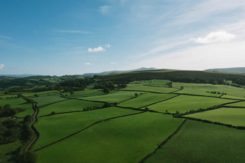
Aerial stills can show farm buildings, fields, access, boundaries and neighbouring land together. Livestock, workers, roads and land access are considered as part of the plan.
Tourism and countryside locations
Accommodation, attractions, estates and outdoor businesses around Llandovery can use the surrounding countryside as useful visual context, with the operating position chosen around the actual site.
Construction and repeat visits
Site layout, access and visible progress can be recorded from planned viewpoints. Repeat visits can use similar positions so change is easier to compare over time.
Rural and market-town flight planning
Roads, trees, livestock, public areas, slopes and rural access can all affect the operation. The exact address or map pin is checked before attendance.
LLANDOVERY DRONE SERVICES
Aerial photography for farms, property and tourism
From property and farms to tourism, construction, land and commercial filming, we provide practical aerial coverage around Llandovery and Carmarthenshire and South East Wales.
Property & land
Show homes, rural property, grounds, fields and access with clear aerial views that make the layout and setting easier to understand.
Tourism & hospitality
Accommodation, attractions, venues and visitor businesses can use Llandovery’s market-town character and surrounding countryside as genuine location context.
Construction & commercial
Document developments, farms, business premises, external works and visible progress around Llandovery and the surrounding countryside.
Roof & site inspections
Focused aerial stills can show roofs, elevations, chimneys and hard-to-see areas, subject to a safe operating position with clear visibility.
LLANDOVERY & CARMARTHENSHIRE & MID WALES
Use aerial views to explain land and setting
The strongest aerial is not simply the highest or widest shot. Around Llandovery, the useful view often shows how a property, farm, estate or visitor location relates to surrounding fields, roads, buildings and countryside.
Property, farms and estates
Wider stills can show boundaries, outbuildings, fields, gardens, access and neighbouring features in a single view.
Tourism and accommodation
Hotels, holiday accommodation, venues and visitor businesses can use the surrounding Carmarthenshire landscape to give the location a clear sense of place.
Agriculture and construction
Farms, developments and working sites can show buildings, yards, access, land and site layout without losing the practical relationship between them.
Ground plus aerial production
Interviews, sound, ground-camera sequences and editing can be added when a property, construction or commercial film needs explanation as well as aerial context.
DRONE COVERAGE AROUND LLANDOVERY
Llandovery and north-east Carmarthenshire
Coverage includes Llandovery itself and nearby rural communities for farms, property, tourism, construction, inspections and commercial work.
Llandovery town & outskirts
Property, shops, tourism, roof inspections, events and commercial projects in and around Llandovery.
Myddfai & Rhandirmwyn
Farms, estates, rural property, accommodation and outdoor projects north and east of Llandovery.
Cilycwm & Llanwrda
Property, farmland, construction and rural businesses around Cilycwm, Llanwrda and nearby communities.
Llangadog & the Tywi Valley
Farms, land, estates, property and tourism projects south towards Llangadog and the upper Tywi Valley.
Llandeilo direction
Coverage extends south-west towards Llandeilo for estates, tourism, property and commercial assignments.
Brecon & Powys direction
Projects can extend east towards Brecon and neighbouring Powys for property, agriculture, tourism and commercial work.
Builth Wells & Mid Wales
For larger Mid Wales assignments, coverage can continue north-east towards Builth Wells and the surrounding rural area.
Wider Carmarthenshire
Work elsewhere in the county can be covered as part of our wider Carmarthenshire service.
HOW A LLANDOVERY DRONE SHOOT WORKS
Simple planning before the drone goes up
Send us the location, what you need photographed or filmed and how the material will be used. We can then plan the right aircraft, shots and operating position before attendance.
01
Send the exact location
Include the required stills or video, intended use and any useful access or landowner information.
02
Plan the flight
We check the site, airspace, access, weather and the shots needed before attendance.
03
Capture the required angles
We work through the agreed stills or video shots efficiently, adapting the flight position where the site requires it.
04
Receive organised files
Edited photographs, agreed clips or source footage are supplied digitally for marketing, reporting, property or production use.
LLANDOVERY DRONE FAQ
Practical questions
Mini 5 Pro or Mavic 4 Pro?
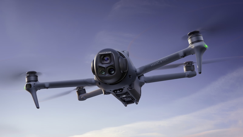
The DJI Mini 5 Pro is particularly useful in the more congested parts of Llandovery town, where its compact 249g-class design gives us greater operational flexibility while still producing professional high-resolution photography and 4K video.
For cinematic filming in wide-open spaces, the DJI Mavic 4 Pro is the stronger choice. Its larger camera system, 6K capability and additional telephoto perspectives suit , farms, estates, countryside tourism and broad Carmarthenshire and South East Wales establishing shots.
Can you fly in Llandovery town?
Potentially. Roads, pedestrians, buildings, private land, the take-off point, nearby people and current airspace information all affect what can be achieved at a particular address.
Can you film farms, estates and rural property?
Yes. Farms, estates and rural property are well suited to aerial stills and video where the client needs to show buildings, fields, access, boundaries and setting. Livestock, workers, roads and neighbouring property are considered before flight.
Can you inspect roofs and buildings?
Yes. Focused aerial stills can show tiles, chimneys, gutters, flat roofs and elevations. If a roofer, surveyor or facilities team has specific areas they need to see, send the brief in advance.
Can you make repeat progress visits?
Yes. Repeat visits can be planned around project milestones and similar viewpoints so visible change is easier to compare. Site activity and weather can still require small adjustments.
What if the weather is unsuitable?
Wind, rain, low cloud and visibility can all affect the flight. Where possible, we use a practical weather window or move the aerial work to a better date.
DRONE PHOTOGRAPHY LLANDOVERY
Need aerial coverage around Llandovery?
Send the location and tell us what you need. A map pin, brief shot list or example image is useful for planning the aerial shoot.