
CIVIL ENGINEERING DRONE PHOTOGRAPHY & VIDEO ACROSS WALES
AERIAL PHOTOGRAPHY FOR CIVIL ENGINEERING & INFRASTRUCTURE
Planned drone photography and aerial video for highways, structures, earthworks, drainage, utilities and infrastructure projects across Wales and the UK.
Capture the scale of the scheme, document specialist operations, build a useful progress record and give project teams or stakeholders visual evidence that is easy to understand.
OPERATIONAL CIVIL ENGINEERING EXPERIENCE
Built around live infrastructure work
GVC + A2 CofC qualified
£1m public liability insurance
High-resolution aerial photography
4K / 6K aerial video
Repeat progress visits
Night operations where the site allows
RAMS / site coordination where required
Existing project experience includes
South Wales Trunk Road Agent (SWTRA)
Welsh Government Highways Department
Overnight M4 resurfacing / echelon paving
| INFRASTRUCTURE COVERAGE PLANNING | WHAT DOES THE PROJECT TEAM NEED TO SEE? |
Plan the flight around the operation, not around impressive angles

Define the engineering activity that matters
Resurfacing, drainage, earthworks, a bridge lift and a general progress update all need different viewpoints. The brief should identify the operation or relationship that the imagery must explain.
Coordinate with traffic management and the live programme
Work windows, live traffic, road closures, site vehicles, plant, workers and public interfaces affect where and when the aircraft can operate. The filming plan is coordinated around the scheme rather than asking the scheme to stop for the camera.
Treat night operations as a separate flight problem
Low light changes visibility, exposure, practical operating positions and how the site reads on camera. Overnight coverage is planned specifically for those conditions rather than treated like a daytime job after dark.
Repeat only the views that remain useful
For longer schemes, consistent reference views help comparisons. Additional photographs should respond to the current phase rather than mechanically recreating every angle on every visit.
Keep visual evidence separate from engineering assessment
Aerial imagery can provide valuable visual evidence of difficult areas and site relationships. It does not replace any formal structural, engineering or specialist inspection required by the project.
CIVIL ENGINEERING AERIAL SERVICES
Four ways aerial coverage supports an infrastructure project
Each service has a different purpose, so the shot list can stay focused rather than becoming a generic collection of site views.
Highways & roadworks
Document resurfacing, lane closures, junction works, traffic management and specialist road operations with enough context to understand the whole work area.
Structures & infrastructure
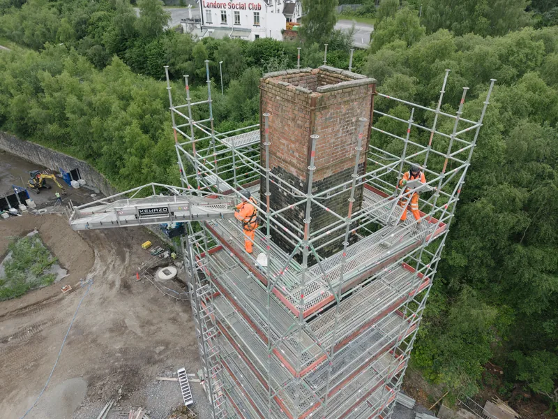
Capture bridges, drainage, retaining structures, earthworks, utilities corridors and other engineering elements where the relationship between components matters.
Progress & reporting
Build a repeat visual record for project managers, clients and stakeholders, with selected images ready for progress reports and internal updates.
Inspection & communication
Record difficult viewpoints for specialist review, or turn technically complex work into clear visual material for public, client and project communications.
REAL HIGHWAYS COVERAGE
Overnight M4 resurfacing and echelon paving
Existing project examples are retained here rather than replacing real evidence with generic stock imagery.
Explain the method, not just the machinery
Echelon paving uses multiple paving machines working side by side. Aerial coverage can show that relationship, the active lane area and the wider closure far more clearly than isolated close-ups.
Coverage planned for the night work window
The useful shots have to fit around live operations, safety, lighting and the available closure period. The camera is there to document the engineering work without becoming an obstacle to it.
DELIVERY OPTIONS
Files for engineering, reporting and communications
Edited high-resolution photographs
4K / 6K aerial footage
Repeat progress viewpoints
Organised source footage
Short progress / stakeholder edits
Selected inspection imagery
Public-facing project films
Completed-project case-study aerials
WHO NEEDS THE MATERIAL?
The same operation can serve several project audiences
Project managers and contractors may need a concise visual record. Consultants and engineers may need specific high-level views for review. Clients and public bodies may need progress explained clearly. Communications teams may want technically important work turned into material the public can understand.
Capture once, deliver appropriately
The flight can produce evidence and communication material in the same work window, but the deliverables should be organised around their eventual users rather than mixed together as one large folder.
Related services
For building-led progress coverage see construction drone photography. For larger development sites see land development aerial services.
NEED GROUND CAMERAS AS WELL?
Interviews, site activity and ground-level engineering footage can be added through South Wales Video
Drone South Wales can provide the aerial photography and footage as a standalone civil-engineering service. When the project also needs interviews, machinery details, workers, sound or a finished case-study film, the ground and aerial shot lists can be planned as one production.
See ground + aerial construction and infrastructure filming →
CIVIL ENGINEERING DRONE COVERAGE ACROSS SOUTH WALES
Infrastructure aerial photography planned around the scheme location
Send the exact scheme location, work window and site contact. Highways, rail-adjacent sites, bridges, utilities and urban infrastructure can each create different operational constraints.
Cardiff
Urban infrastructure, highways, drainage and engineering work around Cardiff and Cardiff Bay, with airspace, traffic and public interfaces considered during planning. Cardiff drone services.
Newport and Cwmbran
Swansea and Bridgend
Caerphilly, Merthyr and the Valleys
Road, drainage, retaining, regeneration and hillside infrastructure across Caerphilly, Merthyr Tydfil, Pontypridd and the Valleys. Caerphilly · Merthyr Tydfil.
Abergavenny and Monmouthshire
Roads, utilities, structures and rural infrastructure around Abergavenny, Monmouth, Usk and the wider county. Abergavenny · Monmouthshire.
Brecon and Powys
Carmarthenshire and Pembrokeshire
Road, utilities, structures and engineering projects across West Wales, where weather, coast and larger rural operating areas can affect the plan. Carmarthenshire · Pembrokeshire.
Across Wales and the UK
Civil-engineering coverage can extend into Mid Wales, the border counties and elsewhere in the UK when the scheme and work window justify travel. Send the exact location for an operational assessment.
HOW CIVIL ENGINEERING COVERAGE WORKS
A practical route from scheme information to usable files
The flight is fitted around the engineering programme rather than treated as a separate event.
01
Send the scheme information
Share the exact location, programme, work window, site contact, activity to be covered, required views and final audience.
02
Coordinate the operation
Airspace, access, traffic, lighting, plant, workers, road closures, permissions, RAMS and safe operating positions are assessed around the live project.
03
Capture the required evidence
The pilot works through the agreed priorities efficiently, adapting to changing site conditions without losing sight of the engineering activity the brief is intended to document.
04
Supply files for the intended audience
Receive edited photographs, organised source footage or finished updates in the format agreed for technical review, reporting, stakeholder communication or promotion.
CIVIL ENGINEERING DRONE FAQ
Questions before booking aerial infrastructure coverage
Send the scheme location and work window when asking for advice. The practical operating environment is as important as the type of engineering project.
Can you work during overnight road closures?
Yes. The existing portfolio includes overnight M4 resurfacing work. Any future night operation is still assessed individually for airspace, lighting, weather, permissions, traffic management and safe operating positions.
Can you repeat the same viewpoints during a long project?
Yes. Practical reference views can be established and repeated where changing structures, cranes, access, traffic and other site conditions allow.
Can drone imagery replace a formal engineering inspection?
No. It can provide valuable visual evidence and access to difficult viewpoints, but it does not replace any legally required engineering, structural or specialist assessment.
Can a surveyor or engineer direct the aerial inspection views?
Yes. A specialist can provide a shot list in advance or request additional views on site where safe and practical, while the pilot remains responsible for the operation of the aircraft.
Can you supply both high-resolution photographs and aerial video?
Yes. The same visit can include high-resolution stills and 4K / 6K aerial footage where the work window and available flight time allow.
Can you provide RAMS and coordinate with the site team?
Yes, where required. Project-specific documentation and site requirements should be supplied in advance so they can be reviewed before the work window.
Can you work around live traffic and active plant?
Often, subject to the actual operation. Traffic, workers, plant movements, temporary restrictions and the available operating area are assessed with the site contact as part of the flight plan.
Can aerial imagery be used in stakeholder and public communications?
Yes. Wide aerial views are useful for explaining scale, sequencing and site relationships to people who are not physically on the project. Edited photographs or short films can be prepared for reports, presentations, websites and consultations.
Can you provide raw footage to our agency or communications team?
Yes. Organised source footage can be supplied for an external edit, or finished photographs and edited aerial sequences can be delivered instead.
Can ground cameras and interviews be included?
Yes. For project films that require interviews, machinery details, workers, sound and ground-level activity as well as drone footage, use South Wales Video’s construction filming service.
How quickly can civil engineering material be supplied?
Turnaround is agreed around the reporting or communications deadline. Urgent delivery can often be planned in advance where the volume of files and transfer arrangements permit it.
What happens if weather or the engineering programme changes?
Flights only proceed when they can be completed safely and legally. Wind, rain, temporary restrictions, traffic management, programme changes or changed access can alter the plan, particularly on short night work windows.
CIVIL ENGINEERING DRONE SERVICES WALES
Have a scheme or work window that needs to be documented clearly from the air?
Send the exact location, programme, activity, site constraints and intended audience. The response can then be based on the actual engineering operation rather than a generic drone package.