DRONE PHOTOGRAPHY & VIDEO IN BRECON
AERIAL PHOTOGRAPHY & DRONE FILMING BRECON
MJ Films offers professional aerial photography and drone video in Brecon and the surrounding Bannau Brycheiniog area for tourism, property, construction, inspections and commercial projects.
Based around 25 minutes from Brecon, we can respond quickly when a useful weather window opens. The town, Usk Valley and surrounding mountains create strong aerial possibilities, but every flight is planned around the actual site and purpose.

LOCAL BRECON COVERAGE
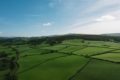
Town + countryside + mountains
GVC + A2 CofC qualified
✓ Commercial drone insurance
✓ High-resolution aerial stills
✓ 4K/6K aerial video
✓ Flight planning included
✓ Fast local response
| BRECON FROM ABOVE | TOWN • VALLEY • NATIONAL PARK |
Aerial coverage in Powys
The landscape gives useful context
For property, tourism and venues, wider aerial views can show how a site relates to Brecon, the Usk Valley and surrounding hills without turning the job into generic landscape photography.
Town flights need a different plan
Brecon town centre brings roads, pedestrians, buildings and busy public areas into the operation. A compact aircraft may be appropriate where the location and regulations allow it.
Mountain weather can change the flight window
Wind, cloud and visibility can change quickly around higher ground. Being close to Brecon makes it easier to use a suitable weather window rather than forcing a flight in poor conditions.
Events need controlled aerial coverage
Outdoor races, shows and organised events can benefit from establishing views, route context and venue coverage, with the flight plan built around participants, spectators and the event layout.
National Park locations are assessed individually
Access, landowner requirements, wildlife, visitors and the exact operating location can all affect what is practical. Send the map pin and intended shot so the site can be checked properly.
BRECON DRONE SERVICES
Aerial work for practical and promotional projects
Coverage is planned around what the finished photographs or footage actually need to communicate.
Tourism & hospitality
Hotels, accommodation, attractions, activity providers and venues can use aerial views to connect the business with Brecon and the surrounding landscape.
Property & land
Show homes, farms, estates, grounds, access and larger plots with views that communicate scale and setting clearly.
Construction & progress
Document developments, external works, access and visible progress with planned viewpoints that can be repeated over time.
Roof & site inspections
Capture roofs, elevations, structures and hard-to-see areas with focused imagery for review without unnecessary material.
A DISTINCTIVE MID WALES LOCATION
Brecon works for more than landscape shots
The scenery is an obvious asset, but useful commercial aerial work is usually about explaining a place, property, route or activity more clearly.
Tourism and outdoor activity
Aerial establishing shots can show venues, accommodation, event routes and activity locations within their real surroundings.
Rural property and farms
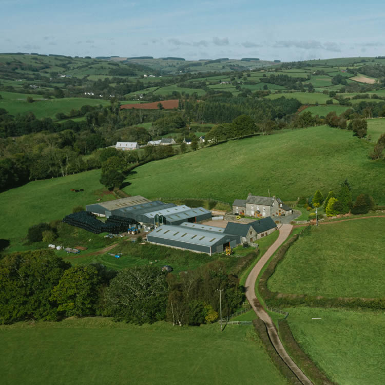
Wider views can show buildings, fields, access, boundaries and neighbouring features that are difficult to understand from ground level.
Events around Brecon
The existing Brecon page’s Race The Sun work reflects the area’s suitability for outdoor event coverage where scale and route geography matter.
Commercial and construction
Industrial units, developments and working sites around Brecon can use aerial photography for progress, marketing and site context.
DRONE COVERAGE AROUND BRECON
Brecon and the surrounding communities
Coverage extends through the Usk Valley and nearby villages, with separate pages used where the site already has a dedicated location page.
Brecon town & Llanfaes
Property, businesses, events, schools, hospitality and construction in and around the town can use aerial coverage where the operating environment allows it.
Llanfrynach, Pencelli & Talybont-on-Usk
Tourism, rural property, farms, canal-side businesses and outdoor projects east of Brecon can benefit from wider valley and mountain context.
Llangorse, Bwlch & the eastern approaches
Visitor businesses, outdoor activities, farms, accommodation and larger properties can use aerials to explain their setting and access.
Crickhowell & the A40 corridor
For projects further east, see the dedicated Crickhowell drone photography page.
Libanus, Defynnog & Sennybridge
Rural businesses, farms, land, accommodation and construction west of Brecon can require careful checks around terrain, access and local activity.
Talgarth & north-east of Brecon
Property, tourism, agriculture and commercial projects around Talgarth and the Black Mountains can be covered from the Brecon area.
Hay-on-Wye & the Wye Valley
For Hay and its surrounding border countryside, see the dedicated Hay-on-Wye drone photography page.
Wider Powys
For Builth Wells, Llandrindod Wells, Newtown and other locations across the county, see our Powys drone photography page.
HOW A BRECON DRONE SHOOT WORKS
Local enough to make use of the right conditions
Send the exact location and required views first. For rural sites, a map pin or What3Words location is often more useful than a postcode.
01
Send the site and brief
Provide the address or map pin, preferred date, required photographs or movements and intended use.
02
Check the operating environment
Airspace, terrain, access, weather, people, nearby property and the practical take-off area are assessed.
03
Capture the priority views
The flight works through the agreed stills, inspection areas or planned video movements while adapting to conditions.
04
Receive organised files
Edited photographs, agreed clips or source footage are supplied digitally for marketing, reporting, property or production use.
DRONE PHOTOGRAPHY & VIDEO BRECON
Need aerial coverage in or around Brecon?
Send the exact location, preferred date and what the photographs or footage need to show.